
If you’re thinking about an addition to your home, cutting some trees down to make way for a pool or just want to know where the lot lines are between you and your neighbors, here’s a great mapping tool to use. The Norwell Municipal Mapper, often called “MuniMapper” is a mapping tool created by MassGIS and available through the Town of Norwell website for residents to use.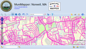
MuniMapper provides access to a selection of map information from the MassGIS statewide repository that is specifically relevant to Norwell. MuniMapper provides basic capabilities for displaying, searching, and sharing map information relevant to municipalities. Of particular interest, you can click on various map layers such as zoning and overlay districts in town, wetlands, conservation, waterways, dams, open space, aquifer protection zones, sidewalks, pathways, trails, tax assessor data, municipal buildings and so much more.
As a Realtor in Norwell, I use the Munimapper quite often just to see the lay of the land and where the wetlands are when doing research on a client’s property. It’s a helpful tool and the Town of Norwell and Commonwealth of Massachusetts GIS provides free use, so give it a try next time you just want to poke around or if you have an upcoming project for your property that might trigger plans and Town approval.